Release notes version 3.15

Software Improvements and Bug Fixes

  • improvement to the JAMS GUI / window layout
  • usability improvements to the Data Explorer
  • added option to define standard output data directory via properties file

New / Improved Model Components

  • jams.components.io.unidata.NetCDFReader, jams.components.io.unidata.TimeIntervalFromNetCDF
    • read spatio-temporal data from from a NetCDF file
    • creates a time interval attribute from a NetCDF file, e.g. for iterating over all of its time steps
  • jams.components.io.TimeIntervalFromDataStore
    • creates a time interval attribute from a datastore, e.g. for iterating over all time steps in an input dataset
  • jams.components.aggregate.MinMax
    • calculates min/max of incoming values
  • jams.components.aggregate.SpatioTemporalAggregator
    • improved aggregation options for spatio-temporal data
  • jams.components.statistics.PercentileCalc
    • caculates percentile values from input data
  • jams.components.io.TemporalShapeEntityWriter
    • improved handling of temporary files
  • jams.components.io.TemporalShapeEntityWriter
    • added function to auto-create subdirectories based on name

Revision 01/02

  • minor issues fixed

Release notes version 3.14

New Model Components

  • org.unijena.j2k.inputData.RecalcLanduseStateVars
    • recalculation of landuse state variables during simulation, e.g. for landuse changes
  • org.unijena.j2k.topology.ReachSubbasin, org.unijena.j2k.topology.SubbasinArea, org.unijena.j2k.io.SubbasinLink
    • extraction of all HRUs belonging to a reach subbasin as a list
    • calculation of the area of a reach subbasin
  • jams.components.indices.SnowLine
    • calculation of snow line elevation

Improvements and Bug Fixes

  • minor bug fixes and improvement to the JAMS runtime system and GUI

Revision 01

  • major bug fix in the J2K_Gehlberg example model: incorrect parallelization config caused varying and wrong spatially aggregated model results

Release notes version 3.13

New Example Model

A new J2K hydrological model for the Dudh Koshi River Basin with all required data and additional components for glacier processes simulation is available in the data folder. Thanks to Santosh Nepal from ICIMOD/Kathmandu for providing this dataset!

New Model Components

  • org.unijena.j2k.regionalisation.Regionalisation_IDW is a component that implements interpolation based on Inverse Distance Weighting (IDW) with the following improvements:
    • Intergrating all required functionality in one component without an additional initialization component, it allows to streamline and simplify model structure.
    • In addition to data interpolation, it allows to calculate and output information about average station distance and station elevation difference at each time step, provoding improved insight into the spatial and temporal distribution of station information density.
  • jams.components.data.DateComponents allows to extract single components from a date object
  • jams.components.data.ScalarToArray allows to collect double scalar(s) into double array(s)
  • jams.components.indices.SPICalc, jams.components.indices.DataColllector and jams.components.indices.DateCollector are components for calculation of Standardized Precipitation Index (SPI) and for collecting respective precip and calendar values
  • jams.components.calc.DoubleArrayMultiply allow to multiply elements in a double array with one or many double values
  • jams.components.data.CalendarComponentChanged allows to detect changes in a component of a date object and thus to perform actions at certain time periods (e.g. monthly, yearly in a daily model)

Improvements and Bug Fixes

  • added support for Datastore outputs of TemporalNestedContext
  • minor bug fixes and improvement to the JAMS runtime system and GUI

Revision 01

  • minor fixes in the Dudh Koshi example model

Release notes version 3.12

New J2K Components

  • org.unijena.j2k.regionalisation.LapseRateRegionalization is a lapse rate component, taking into account distance to stations, missing data and yearly or monthly lapse rates
  • org.unijena.j2k.regionalisation.LapseRateAdaptation can be used in combination with the IDW regionalization to apply a lapse rate approach in the interpolated climatic variable. For this purose, IDW can now output the average (weighted) elevation of the source stations. This elevation can then be used in LapseRateAdaptation to adapt the IDW result according to the elevation difference between the HRU and the source station elevations
Revision 01:
  • added lower/upper  boundary options to org.unijena.j2k.regionalisation.LapseRateRegionalization and org.unijena.j2k.regionalisation.LapseRateAdaptation
Revision 02:
  • fixed bug in org.unijena.j2k.regionalisation.LapseRateRegionalization and org.unijena.j2k.regionalisation.LapseRateAdaptation

Release notes version 3.11_00

Improvements to JAMS

  • added dependencies to run under Java 9 and above

New JAMS Components

  • added support for R integration
  • added components for calculation of indicators (package jams.components.indices), e.g.
    • Indicators of Hydrological Alteration (IHA)
    • Various precipitation indicators including Standardized Precipitation Index (SPI)


Release notes version 3.9_00/01/02

Improvements to JAMS Components

  • added new component jams.components.aggregate.LongTermAggregation for calculating long-term sums or averages
  • added new component jams.components.gui.CategoryPlot that creates a graphical plot of category data, e.g. to compare attributes of different model entities
  • added various components for SMDI/ETDI calculation (https://doi.org/10.1016/j.agrformet.2005.07.012)
  • added component jams.components.calc.EventCounter that allows counting the occurrence of certain states in a model (e.g. SMDI < -3.5)
  • fixed minor bug in jams.components.gui.CategoryPlot

Updated J2K example model

  • added components for long-term temporal aggregation and output
  • added components for Shapefile output of results
  • replaced efficiency calculation component by more versatile version
  • added category plots for efficiencies and water balance

Improvements to JAMS Optas

  • addeed optas.sampler.FileListSampler that allows sampling over a list of given parameter values read from a file
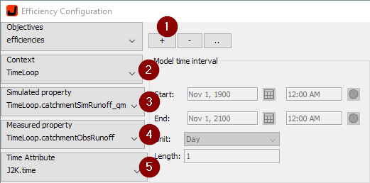
  • fixed minor bug in Efficiency Configurator

Improvements to JAMS Main

  • added option to use minutely time steps


Release notes version 3.7_00

New and updated components

added components to calculate Soil Moisture Deficit Index (SMDI) and Evapotranspiration Deficit Index (ETDI) (see jams.components.indices in jams-components library)

added function to output the impact of indivudual stations within the Inverse Distance Weighting (IDW) regionalization approach, e.g. as XY-plot or as map

Minor bug fixes

  • fixed GUI errrors in WorldWind
  • fixed GUI error in Data Explorer (JADE)