GRASS-HRU/Tutorial
From ILMS-Wiki
(Difference between revisions)
ChristianS (Talk | contribs) (→HNZ Gauging stations) |
ChristianS (Talk | contribs) (→Input data) |
||
| Line 1: | Line 1: | ||
| − | == | + | == Free input data == |
<gallery> | <gallery> | ||
File:SRTM_dem.png|SRTM Elevation | File:SRTM_dem.png|SRTM Elevation | ||
Revision as of 07:28, 26 March 2013
Contents |
Free input data
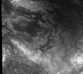
SRTM Elevation
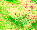
Corine Landcover
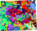
Harmonized World Soil Database
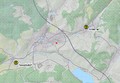
HNZ Gauging stations


SRTM elevation
Corine Landcover
Harmonized World Soil Database
HNZ Gauging stations
Search http://hnz.tlug-jena.de/aktuelle-situation/thueringen.html for gauging stations Rappelsdorf and Hinternah and create a simple text file that contains at least the station coordinates and a whole-number identfier. A header line is advised:
id, name, lat, long
42151, Rappelsdorf, 50.49646395, 10.72495857
42160, Hinternah, 50.51864038, 10.79306017