File list
From ILMS-Wiki
This special page shows all uploaded files. By default the last uploaded files are shown at top of the list. A click on a column header changes the sorting.
| Thumbnail | Name | User | Size | Description | Versions | |
|---|---|---|---|---|---|---|
 | 08:13, 25 May 2011 | Profile 5.png (file) | Christin | 196 KB | 1 | |
 | 11:52, 25 May 2011 | Context examples.png (file) | Christin | 26 KB | 1 | |
 | 07:10, 27 May 2011 | Sources of uncertainty.png (file) | Chr | 66 KB | 1 | |
| 09:59, 27 May 2011 | Ilms img qgis work 13.png (file) | MReinhold | 12 KB | (Dialoge zur Information über Beendigung der Zellbildung) | 1 | |
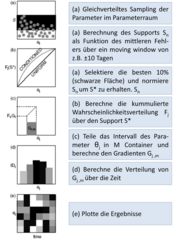 | 16:15, 27 May 2011 | DYNIA1.png (file) | Chr | 175 KB | 1 | |
 | 11:00, 31 May 2011 | Ilms img qgis work 15.png (file) | MReinhold | 25 KB | (Das ILMSImage-Panel zur Berechnung von Zellattributen) | 1 |
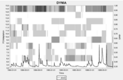 | 20:05, 31 May 2011 | DYNIA.png (file) | Chr | 21 KB | 1 | |
 | 15:58, 4 June 2011 | Crossvalidation.png (file) | Chr | 39 KB | 2 | |
 | 09:48, 22 June 2011 | 1.Schritt ModellDokumentation.png (file) | Christin | 87 KB | 1 | |
 | 09:48, 22 June 2011 | 2.Schritt ModellDokumentation.png (file) | Christin | 78 KB | 1 | |
 | 09:49, 22 June 2011 | 3.Schritt ModellDokumentation.png (file) | Christin | 225 KB | 1 | |
 | 09:49, 22 June 2011 | 4.Schritt ModellDokumentation.png (file) | Christin | 230 KB | 1 | |
 | 09:49, 22 June 2011 | 5.Schritt ModellDokumentation.png (file) | Christin | 225 KB | 1 | |
 | 09:50, 22 June 2011 | Softwaredokumentation.png (file) | Christin | 19 KB | 1 | |
| 13:45, 22 June 2011 | Softwaredokumentation en.png (file) | Christin | 23 KB | 1 | ||
 | 13:45, 22 June 2011 | 1.Schritt ModellDokumentation en.png (file) | Christin | 62 KB | 1 | |
 | 13:45, 22 June 2011 | 2.Schritt ModellDokumentation en.png (file) | Christin | 54 KB | 1 | |
 | 13:46, 22 June 2011 | 3.Schritt ModellDokumentation en.png (file) | Christin | 111 KB | 1 | |
 | 13:46, 22 June 2011 | 4.Schritt ModellDokumentation en.png (file) | Christin | 87 KB | 1 | |
 | 13:46, 22 June 2011 | 5.Schritt ModellDokumentation en.png (file) | Christin | 114 KB | 1 | |
| 13:57, 22 June 2011 | Workspace Dokumentation.png (file) | Christin | 4 KB | 1 | ||
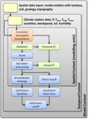 | 12:35, 23 June 2011 | J2000g struktur.jpg (file) | Peter | 286 KB | 1 | |
 | 14:30, 1 August 2011 | Ilms img qgis work 11.png (file) | MReinhold | 9 KB | (Informationen zu einem ILMSImage-Projekt.) | 3 |
 | 14:33, 1 August 2011 | Ilms img qgis work 11a.png (file) | MReinhold | 9 KB | (Informationen zu einem ILMSImage-Projekt.) | 1 |
 | 14:52, 1 August 2011 | Ilms img qgis work 14a.png (file) | MReinhold | 726 KB | (Zellindex als Vektordatenlayer über Originaldaten ) | 2 |
| 15:01, 1 August 2011 | Ilms img qgis work 17.png (file) | MReinhold | 9 KB | (Benachrichtigung bei Abschluss der Attributberechnung ) | 1 | |
 | 12:30, 16 August 2011 | Ilms img qgis work 18.png (file) | MReinhold | 13 KB | (Benachrichtigung und Abfrage nach Abschluss des Attributexports) | 1 |
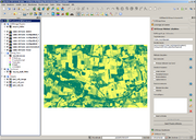 | 12:33, 16 August 2011 | Ilms img qgis work 20.png (file) | MReinhold | 603 KB | (In die Kartenansicht geladener pixelbasierter NDVI-Datensatz) | 1 |
 | 12:48, 16 August 2011 | Ilms img qgis work 21.png (file) | MReinhold | 9 KB | (Tool zur Definition und Bearbeitung externer Datenebenen) | 1 |
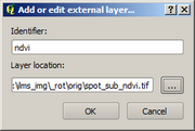 | 12:57, 16 August 2011 | Ilms img qgis work 22.png (file) | MReinhold | 7 KB | (Definition einer neuen externen Datenebene) | 1 |
| 13:04, 16 August 2011 | Ilms img qgis work 23.png (file) | MReinhold | 10 KB | (Benachrichtigung nach Abschluss der Definition einer externen Dateneben) | 1 | |
 | 13:24, 16 August 2011 | Ilms img qgis work 25.png (file) | MReinhold | 14 KB | (Benachrichtigung bei Integration eines Layers mit inkompatiblen Datentyp) | 1 |
| 13:46, 16 August 2011 | Ilms img qgis work 27.png (file) | MReinhold | 10 KB | (Benachrichtigung nach Abschluss der Attributberechnung mit externen Zusatzebenen) | 1 | |
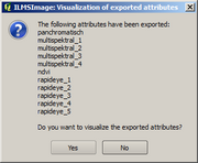 | 13:51, 16 August 2011 | Ilms img qgis work 28.png (file) | MReinhold | 13 KB | (Abfrage zur Visualisierung von mit Zusatzebenen berechneter Attribute) | 1 |
 | 13:56, 16 August 2011 | Ilms img qgis work 29.png (file) | MReinhold | 9 KB | (Abfrage beim Entfernen eines externen Layers aus dem ILMSImage-Projekt) | 1 |
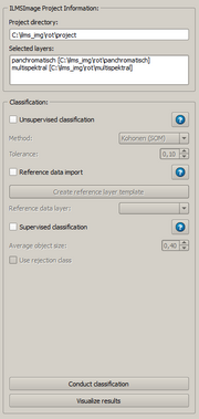 | 11:11, 17 August 2011 | Ilms img qgis work 16.png (file) | MReinhold | 25 KB | (Das ILMSImage-Panel zur thematischen Klassifikation ) | 2 |
 | 09:53, 18 August 2011 | Ilms img qgis work 30.png (file) | MReinhold | 7 KB | (Benachrichtigungsfenster nach Abschluss der unüberwachten Klassifikation) | 1 |
 | 10:47, 18 August 2011 | Ilms img qgis work 32.png (file) | MReinhold | 9 KB | (Auswahldialog zur Erzeugung eines neuen Referenzdatensatzes mit voraussichtlicher Klassenanzahl) | 1 |
| 10:48, 18 August 2011 | Ilms img qgis work 33.png (file) | MReinhold | 9 KB | (Benachrichtigung im Falle, dass der zu erzeugende Referenzdatensatz bereits existiert) | 1 | |
 | 11:42, 18 August 2011 | Ilms img qgis work 34.png (file) | MReinhold | 42 KB | (Umschalten in den Bearbeitungsmodus) | 1 |
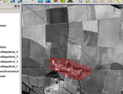 | 12:37, 18 August 2011 | Ilms img qgis work 35.png (file) | MReinhold | 174 KB | (Digitalisieren eines Referenzpolygons) | 1 |
 | 12:38, 18 August 2011 | Ilms img qgis work 37.png (file) | MReinhold | 155 KB | (Vollständiges Referenzgebiet in Zufallsfarbendarstellung) | 1 |
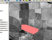 | 12:39, 18 August 2011 | Ilms img qgis work 39.png (file) | MReinhold | 153 KB | (Vollständiges Referenzgebiet in dem Sachverhalt angepasster Darstellung) | 1 |
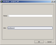 | 12:43, 18 August 2011 | Ilms img qgis work 36.png (file) | MReinhold | 15 KB | (Maske zur Eingabe der Attribute) | 2 |
 | 12:49, 18 August 2011 | Ilms img qgis work 38.png (file) | MReinhold | 43 KB | (Fenster zur Änderung von Darstellungsfarbe und Beschreibung) | 1 |
 | 12:58, 18 August 2011 | Ilms img qgis work 40.png (file) | MReinhold | 580 KB | (Vollständig definierter Referenzdatenlayer überlagert über der Grenze des Untersuchungsgebiets) | 1 |
 | 09:02, 26 August 2011 | Ilms img qgis install 11.png (file) | MReinhold | 18 KB | (Die Liste der zu aktualisierenden Pakete einer OSGeo4W-Installation. ) | 2 |
 | 09:46, 26 August 2011 | Ilms img qgis work 14.png (file) | MReinhold | 277 KB | (Zellindex als Vektordatenlayer über Originaldaten) | 3 |
 | 09:53, 26 August 2011 | Ilms img qgis work 19.png (file) | MReinhold | 248 KB | (Exportierte und in der Kartenansicht visualisierte Attributdatensätze ) | 2 |
 | 11:27, 26 August 2011 | Ilms img qgis work 24.png (file) | MReinhold | 285 KB | (Zur visuellen Kontrolle geladener externer NDVI-Datensatz ) | 2 |
 First page |
 Previous page |
 Next page |
 Last page |