OBIS: getting started
| (31 intermediate revisions by 3 users not shown) | |||
| Line 1: | Line 1: | ||
| + | [[pt:OBIS:_Uma_pequena_Introdução]] | ||
| + | [[Using_the_Okavango_Basin_Information_System_(OBIS)|[Back to tutorial main page]]] | ||
| + | |||
== System access and data overview == | == System access and data overview == | ||
| Line 5: | Line 8: | ||
[[File:OBIS_frontpage.png|600px|OBIS frontpage]] | [[File:OBIS_frontpage.png|600px|OBIS frontpage]] | ||
| − | Two menus (marked in red) offer access to various generic functions (top menu) and data types (left menu). Via the top menu, the following OBIS | + | Two menus (marked in red) offer access to various generic functions (top menu) and data types (left menu). Via the top menu, the following OBIS functions can be accessed: |
| − | * '''Search''': allows to globally search over all | + | * '''Search''': allows to globally search over all data types |
* '''Reporting''': shows lists of recently changed datasets | * '''Reporting''': shows lists of recently changed datasets | ||
* '''Account''': allows to change user specific information (e.g. password or language) | * '''Account''': allows to change user specific information (e.g. password or language) | ||
| Line 14: | Line 17: | ||
The left menu provides access to OBIS data about: | The left menu provides access to OBIS data about: | ||
* '''Persons and organisations''': persons and organizations referred to in metadata of various other data types | * '''Persons and organisations''': persons and organizations referred to in metadata of various other data types | ||
| − | * '''Study sites''': descriptions of locations (i.e. points or areas) | + | * '''Study sites''': descriptions of locations (i.e. points or areas) at which (field) research is located |
| − | * '''Observations''': general field observations done at study sites, used for information not | + | * '''Observations''': general field observations done at study sites, used for information not covered by other data types |
* '''Vegetation''': vegetation observations, can be linked to study sites | * '''Vegetation''': vegetation observations, can be linked to study sites | ||
* '''Soil''': soil observations, can be linked to study sites | * '''Soil''': soil observations, can be linked to study sites | ||
* '''Rivers''': rivers and their tributaries | * '''Rivers''': rivers and their tributaries | ||
* '''Stations''': measurement stations, their location and type (e.g. climate station, streamflow gauge, ...) | * '''Stations''': measurement stations, their location and type (e.g. climate station, streamflow gauge, ...) | ||
| − | * '''Time series data''': time series of measured and simulated data, together with information about their stored parameters, source and data gaps | + | * '''Time series data''': time series of measured and simulated data, together with information about their stored parameters, source, and data gaps |
| − | * '''Geodata''': geospatial data | + | * '''Geodata''': geospatial data, including descriptions of map projection , data type, and other metadata (in accordance with the ISO 19115 standard) |
* '''Scenarios''': general purpose future development scenarios (e.g. related to climate or land use change) | * '''Scenarios''': general purpose future development scenarios (e.g. related to climate or land use change) | ||
* '''Indicators''': environmental indicators and their values suited to evaluate scenarios applied to study sites | * '''Indicators''': environmental indicators and their values suited to evaluate scenarios applied to study sites | ||
* Documents | * Documents | ||
| + | * Glossary | ||
== User account == | == User account == | ||
| − | As a default, users are logged in automatically as a guest user. In OBIS, the guest user account already allows | + | As a default, users are logged in automatically as a guest user. In OBIS, the guest user account already allows access to a variety of functions, including |
| − | * searching for / displaying meta-information | + | * searching for / displaying meta-information about most stored data |
* visualizing interactive maps and previews of geospatial data | * visualizing interactive maps and previews of geospatial data | ||
* displaying previews of time series graphs and images | * displaying previews of time series graphs and images | ||
| − | The guest user is not allowed to access and download detailed information such as time series or geodata. The same holds for accessing restricted and account specific functions like language settings (the guest user uses English | + | The guest user is not allowed to access and download detailed information such as time series or geodata. The same holds for accessing restricted and account specific functions like language settings (the guest user account uses English). For an individual dataset, specific permissions may have been defined by the dataset owner and as such might differ from the default settings. |
| − | Throughout this tutorial, a user account with typical permission settings | + | Throughout this tutorial, a user account with typical permission settings is used. To login with your account, select the ''Login/-out'' link from the top menu. Please fill your user credentials into the form as shown in the image below: |
[[File:OBIS_login.png|600px|OBIS login form]] | [[File:OBIS_login.png|600px|OBIS login form]] | ||
| Line 43: | Line 47: | ||
[[File:OBIS_registration.png|600px|User registration form]] | [[File:OBIS_registration.png|600px|User registration form]] | ||
| − | Please carefully fill in the information about ''Affiliation'' and ''Request notice'' as the permissions granted by the OBIS administrator will be based on and justified by these data. Upon submitting the data, an OBIS administrator is notified about your request. Your account will usually be created within one day and your user credentials will be sent to you via an automated email. | + | Please carefully fill in the information about ''Affiliation'' and ''Request notice'' as the permissions granted by the OBIS administrator will be based on and justified by these data. Upon submitting the data, an OBIS administrator is notified about your request. You may be contacted by the administrator to confirm or expand upon the information you submitted. Your account will usually be created within one day and your user credentials will be sent to you via an automated email. |
| − | Once you have successfully logged in, your currently used user account is displayed | + | Once you have successfully logged in, your currently used user account is displayed below the main menu, e.g. ''Logged in as: skralisch''. In case you are experiencing problems accessing data, please remember to check if the user account shown here is the one you intend to use. To change your user account settings like password, email address, or preferred language, select the ''Account'' link from the top menu. |
| − | [[ | + | [[Using_the_Okavango_Basin_Information_System_(OBIS)|[Back to tutorial main page]]] |
Latest revision as of 15:34, 25 March 2015
System access and data overview
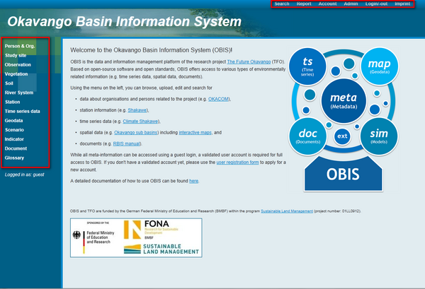
OBIS can be found under http://www.future-okavango.org/obis. Opening it in your favourite web browser you are greeted with the following screen:
Two menus (marked in red) offer access to various generic functions (top menu) and data types (left menu). Via the top menu, the following OBIS functions can be accessed:
- Search: allows to globally search over all data types
- Reporting: shows lists of recently changed datasets
- Account: allows to change user specific information (e.g. password or language)
- Admin: global admministration functions (e.g. user / permission management, system log files)
- Login/-out
The left menu provides access to OBIS data about:
- Persons and organisations: persons and organizations referred to in metadata of various other data types
- Study sites: descriptions of locations (i.e. points or areas) at which (field) research is located
- Observations: general field observations done at study sites, used for information not covered by other data types
- Vegetation: vegetation observations, can be linked to study sites
- Soil: soil observations, can be linked to study sites
- Rivers: rivers and their tributaries
- Stations: measurement stations, their location and type (e.g. climate station, streamflow gauge, ...)
- Time series data: time series of measured and simulated data, together with information about their stored parameters, source, and data gaps
- Geodata: geospatial data, including descriptions of map projection , data type, and other metadata (in accordance with the ISO 19115 standard)
- Scenarios: general purpose future development scenarios (e.g. related to climate or land use change)
- Indicators: environmental indicators and their values suited to evaluate scenarios applied to study sites
- Documents
- Glossary
User account
As a default, users are logged in automatically as a guest user. In OBIS, the guest user account already allows access to a variety of functions, including
- searching for / displaying meta-information about most stored data
- visualizing interactive maps and previews of geospatial data
- displaying previews of time series graphs and images
The guest user is not allowed to access and download detailed information such as time series or geodata. The same holds for accessing restricted and account specific functions like language settings (the guest user account uses English). For an individual dataset, specific permissions may have been defined by the dataset owner and as such might differ from the default settings.
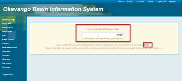
Throughout this tutorial, a user account with typical permission settings is used. To login with your account, select the Login/-out link from the top menu. Please fill your user credentials into the form as shown in the image below:
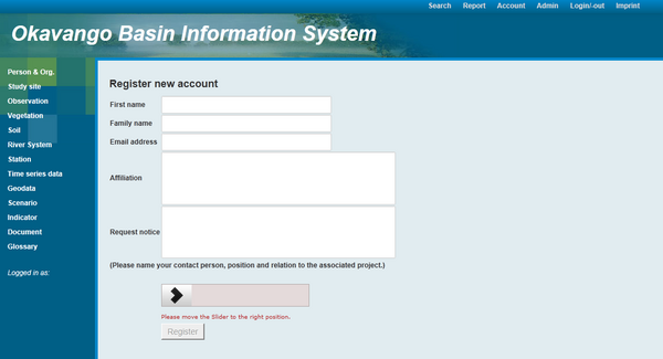
If you don't have an account yet, please select the Request new user account link from the same page and provide the required information in the following form as shown here:
Please carefully fill in the information about Affiliation and Request notice as the permissions granted by the OBIS administrator will be based on and justified by these data. Upon submitting the data, an OBIS administrator is notified about your request. You may be contacted by the administrator to confirm or expand upon the information you submitted. Your account will usually be created within one day and your user credentials will be sent to you via an automated email.
Once you have successfully logged in, your currently used user account is displayed below the main menu, e.g. Logged in as: skralisch. In case you are experiencing problems accessing data, please remember to check if the user account shown here is the one you intend to use. To change your user account settings like password, email address, or preferred language, select the Account link from the top menu.


