GRASS-HRU/Tutorial
Contents |
Free input data
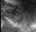
SRTM Elevation
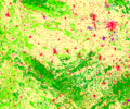
Corine Landcover
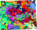
Harmonized World Soil Database
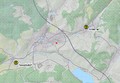
HNZ Gauging stations


SRTM elevation
Corine Landcover
Download the CLC 2006 - 100m dataset from http://www.eea.europa.eu/data-and-maps/data/corine-land-cover-2006-raster-2. The resulting GeoTiff file you can load into QGIS.
Harmonized World Soil Database
HNZ Gauging stations
Search http://hnz.tlug-jena.de/aktuelle-situation/thueringen.html for gauging stations Rappelsdorf and Hinternah and create a simple text file that contains at least the station coordinates and a whole-number identfier. A header line is advised:
id, name, lat, long
42151, Rappelsdorf, 50.49646395, 10.72495857
42160, Hinternah, 50.51864038, 10.79306017
Using Layer > Add delimited text layer in QGIS, you can easily import the stations as a layer and convert it into a Shapefile as required by GRASS-HRU: Right-click on imported layer and save it to a new Shapefile. Do not forget to specify the desired target coordinate reference system, here EPSG:32632 (WGS84/UTM zone 32N).
Result: tbd