GRASS-HRU/Tutorial
ChristianS (Talk | contribs) (→Free input data) |
ChristianS (Talk | contribs) |
||
| Line 1: | Line 1: | ||
== Free input data == | == Free input data == | ||
<gallery> | <gallery> | ||
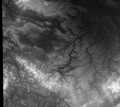
| − | File:SRTM_dem.png|SRTM Elevation | + | File:SRTM_dem.png|SRTM Elevation |
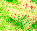
| − | File:Corine_landcover.png|Corine Landcover | + | File:Corine_landcover.png|Corine Landcover |
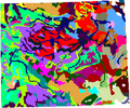
| − | File:HWSD_soil.png|Harmonized World Soil Database | + | File:HWSD_soil.png|Harmonized World Soil Database |
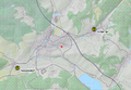
File:Pegel.png|HNZ Gauging stations | File:Pegel.png|HNZ Gauging stations | ||
</gallery> | </gallery> | ||
=== SRTM elevation === | === SRTM elevation === | ||
| + | * resolution: 90 meter | ||
| + | * CRS: EPSG:4326 - WGS84 | ||
=== Corine Landcover === | === Corine Landcover === | ||
| + | * resolution: 100 meter | ||
| + | * CRS: EPSG:3035 - ETRS89 | ||
Download the '''CLC 2006 - 100m''' dataset from http://www.eea.europa.eu/data-and-maps/data/corine-land-cover-2006-raster-2. The resulting GeoTiff file you can load into QGIS. Use ''Raster > Extraction > Clipper'' to cut in advance. Extent coordinates of '''x1:4311011.14124, y1:3172437.46652, x2:4508461.13837 and y2:3009522.44988''' would be a good choice in order to keep the area of Thuringia. At the end, reproject to the target spatial refernce system (''Raster > Projections > Warp'') - in our case EPSG:32632 (WGS84/UTM zone 32N). | Download the '''CLC 2006 - 100m''' dataset from http://www.eea.europa.eu/data-and-maps/data/corine-land-cover-2006-raster-2. The resulting GeoTiff file you can load into QGIS. Use ''Raster > Extraction > Clipper'' to cut in advance. Extent coordinates of '''x1:4311011.14124, y1:3172437.46652, x2:4508461.13837 and y2:3009522.44988''' would be a good choice in order to keep the area of Thuringia. At the end, reproject to the target spatial refernce system (''Raster > Projections > Warp'') - in our case EPSG:32632 (WGS84/UTM zone 32N). | ||
| Line 15: | Line 19: | ||
=== Harmonized World Soil Database === | === Harmonized World Soil Database === | ||
| + | * resolution: 100 meter | ||
| + | * CRS: EPSG:4326 - WGS84 | ||
| + | From http://webarchive.iiasa.ac.at/Research/LUC/External-World-soil-database/HTML/HWSD_Data.html download the zipped raster in ESRI BIL format (unzipped about 1.8GB!). As the format is supported by GDAL you can open it in QGIS and cut it afterwards (like landcover map above) - Pay attention to source projection (WGS84) when cutting and transforming the map extract (e.g. Thuringia again) to desired reference system. | ||
=== HNZ Gauging stations === | === HNZ Gauging stations === | ||
Revision as of 10:53, 26 March 2013
Contents |
Free input data
SRTM Elevation
Corine Landcover
Harmonized World Soil Database
HNZ Gauging stations


SRTM elevation
- resolution: 90 meter
- CRS: EPSG:4326 - WGS84
Corine Landcover
- resolution: 100 meter
- CRS: EPSG:3035 - ETRS89
Download the CLC 2006 - 100m dataset from http://www.eea.europa.eu/data-and-maps/data/corine-land-cover-2006-raster-2. The resulting GeoTiff file you can load into QGIS. Use Raster > Extraction > Clipper to cut in advance. Extent coordinates of x1:4311011.14124, y1:3172437.46652, x2:4508461.13837 and y2:3009522.44988 would be a good choice in order to keep the area of Thuringia. At the end, reproject to the target spatial refernce system (Raster > Projections > Warp) - in our case EPSG:32632 (WGS84/UTM zone 32N).
Result: tbd
Harmonized World Soil Database
- resolution: 100 meter
- CRS: EPSG:4326 - WGS84
From http://webarchive.iiasa.ac.at/Research/LUC/External-World-soil-database/HTML/HWSD_Data.html download the zipped raster in ESRI BIL format (unzipped about 1.8GB!). As the format is supported by GDAL you can open it in QGIS and cut it afterwards (like landcover map above) - Pay attention to source projection (WGS84) when cutting and transforming the map extract (e.g. Thuringia again) to desired reference system.
HNZ Gauging stations
Search http://hnz.tlug-jena.de/aktuelle-situation/thueringen.html for gauging stations Rappelsdorf and Hinternah and create a simple text file that contains at least the station coordinates and a whole-number identfier. A header line is advised:
id, name, lat, long
42151, Rappelsdorf, 50.49646395, 10.72495857
42160, Hinternah, 50.51864038, 10.79306017
Using Layer > Add delimited text layer in QGIS, you can easily import the stations as a layer and convert it into a Shapefile as required by GRASS-HRU: Right-click on imported layer and save it to a new Shapefile. Do not forget to specify the desired target coordinate reference system, here EPSG:32632 (WGS84/UTM zone 32N).
Result: tbd